By Burt Rutherford Contributing Editor
Adios El Niño and howdy La Niña. That’s the weather event that will shape, by and large, what happens in 2024, said Brian Bledsoe, meteorologist and ag weather consultant.
“That transition is maybe the single-most important seasonal weather forecast metric that there’s going to be,” he told beef producers attending the Range Beef Cow Symposium in Loveland, Colo., in December. “When El Niño departs and when La Niña comes back and when that transition zone is, is going to mean everything in 2024 when it comes to weather,” Bledsoe said.
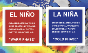
That’s because of the general effect these two events have on the weather. El Niño has been the major player in the weather world over the past several years, but it will give way to La Niña as winter wanes and spring hits the Northern Hemisphere.
“The trend is, once we see El Niño on its way out and La Niña coming back into the fray, you start drying out from south to north,” he said. The transition to La Niña will likely take place this spring through the summer.
“We’re probably going to linger this El Niño through February, maybe March, then it’s rapidly going to go away. That doesn’t necessarily mean it’s all bad right away, because those ocean temperatures still have to cool down,” he said. “I get more concerned when ocean temperatures start getting cold enough that they’re below average. And that no doubt will start commencing … later this spring and certainly thereafter. While it’s not a slam dunk, I would definitely be prepared for renewed drought later in ’24, especially for the southern parts of the region.”
There’s a caveat in the long-term weather outlook, however. “I went back to 1950 and I cannot find one single year in history that matches up with the way we have things going right now,” he said. “So when you’re looking back through history, trying to paint a picture of what this could look like going forward, you’re not going to find one.”
With that in mind, here’s a look at the forecast for the first half of the year. “In general, the southern tier states, the midsection of the country and southward will probably do OK through April.” For February, he predicts a wet pattern coming down through the central and south-central parts of the country. “California is still doing OK. The north-central part of the country struggles.”
That’s because El Niño’s grip is still firm. “The El Niño pattern has kept [northern states] warmer than average and also largely kept them drier than average. I don’t see that changing, at least during the heart of this winter,” he said. “
If we look at March, the western part of the country is still showing some activity.” Going to April, he sees a similar trend. “Some patchy wetness, some patchy dryness in the midsection.”
The trend will continue through May. El Niño will be gone by May and the transition to La Niña will be underway. “There’s some ugliness starting to show up in the western United States during June,” he predicted. “I’m not saying that June is going to be a wreck. The trend is your friend, so when you start seeing some things line up, then maybe it’s time to be a little bit measured about how you go forward as the transition takes place.”
The weather outlook will remain unsettled as the transition from El Niño to La Niña occurs. “If we have a moisture failure in the next six months, we’re going to have problems, pretty significant ones, during the back half of ’24 and likely going into ‘25,” he said.
Why So Much Drought?
Those with some chronological experience look back at the ‘70s through the mid to late ‘90s with warm memories as the recent golden age for agriculture in the Plains. That’s because of the Pacific Decadal Oscillation or PDO, Bledsoe said. The PDO was in a warm phase throughout those years and the weather responded positively. “Around 1998, the Pacific changed. We’ve been in a steady state or negative or cold PDO for the past 25 years. You want to know why we’ve had more drought than not? Look no further than the PDO.”
What’s more, he said that when the PDO is cold and negative, we see more frequent and longer lasting La Niña episodes. “We can still get an El Niño in there, they’re just short-lived and their staying power isn’t strong.”
Given the outlook for renewed drought the last half of the year, now is a good time to update your drought management plan. “You need to be very judicious with your moisture and your plan going forward,” he stressed. “Because how we finish 2024 is likely not going to be how we started.”